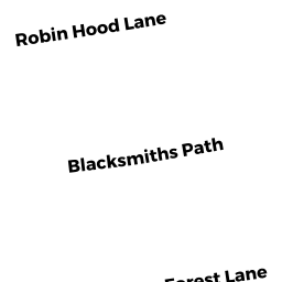
0 ROBIN HOOD LANE
Owner Information
NEWKIRK SCOTT
NEWKIRK GREG
JOPPA, MD 21085 1115


Property Details
0 ROBIN HOOD LANE is classified as a Developable Residential Land.
0 ROBIN HOOD LANE is valued at $6,900. The land is valued at $6,900 and the structures are valued at $0.
This property is in Zone R1. Confirm with local Zoning Board authorities to ensure there are no overlays or other easements on this property.
The most recent deed for 0 ROBIN HOOD LANE is recorded at the local registrar in Book 3417, Page 58. 0 ROBIN HOOD LANE was last sold on Tuesday, December 20, 2005 for $1.
Assessment data from fiscal year 2020.
Flood Data
According to the FEMA National Flood Hazard Layer, this property does not appear to be in a flood zone. It may also be in an area not yet reviewed. Nonetheless, confirm this information prior to taking any action.
To view the flood hazards around this property, create a FEMA "Firmette" Map of the area around 0 ROBIN HOOD LANE.
Broadband Internet Providers
| Provider | Type | Bandwidth (mbps) | |
|---|---|---|---|
| Viasat Inc | Satellite | 35 | 3 |
| VSAT Systems, LLC. | Satellite | 2 | 1 |
| HughesNet | Satellite | 25 | 3 |
| GCI Communication Corp. | Satellite | 0 | 0 |
| T-Mobile | Fixed Wireless | 25 | 3 |
| Verizon New England Inc. | DSL | 5 | 0 |
Broadband service provider data from December 2020.
Adjacent Properties
- 72 BLACKSMITHS PATH
Single Family Residential owned by NABOZNY DEBRA - 0 BLACKSMITHS PATH
(formerly Municipalities/Districts. Removed June 2009.) owned by TOWN OF BECKET - 85 ROBIN HOOD LANE
Single Family Residential owned by SZABO PAL - 0 ROBIN HOOD LANE
Developable Residential Land owned by ALVES JOAO & CHRISTINA - 0 BLACKSMITHS PATH
Vacant, Selectmen or City Council (Municipal) owned by TOWN OF BECKET